
07 September 2009
Patmos

Patmos (Greek, Πάτμος; Italian: Patmo) is a small Greek island in the Aegean Sea. One of the northernmost islands of the Dodecanese complex, it has a population of 2,984 and an area of 34.05 km (13 square miles). The highest point is Profitis Ilias, 269 meters above sea level. The Municipality of Patmos, which includes the offshore islands of Arkoi (pop. 54), Marathi (pop. 6), and several uninhabited islets, has a total population of 3,044 (2001 census) and a combined land area of 45.039 km².
Patmos' main communities are Chora (the capital city), and Skala, the only commercial port. Other settlements are Grikou and Kampos. The churches and communities on Patmos are of the Eastern Orthodox tradition. In 1999, the island's historic center Chora, along with the Monastery of Saint John the Theologian and the Cave of the Apocalypse, were declared World Heritage Sites by UNESCO.The monastery was founded by Saint Christodulos. Patmos is also home to the Patmian School, a notable Greek seminary.
Patmos is mentioned in the Christian scriptural Book of Revelation. The book's introduction states that its author, John, was on Patmos when he was given (and recorded) a vision from Jesus. Earliest Christian tradition identifies this writer as John the Apostle. As such, Patmos is a destination for Christian pilgrimage. Visitors can see the cave where John is said to have received his Revelation (the Cave of the Apocalypse), and several monasteries on the island are dedicated to Saint John.
Gulls (Seagulls)

Gulls (often informally seagulls) are birds in the family Laridae. They are most closely related to the terns (family Sternidae) and only distantly related to auks, skimmers, and more distantly to the waders. Until recently, most gulls were placed in the genus Larus, but this arrangement is now known to be polyphyletic, leading to the resurrection of several genera.
They are typically medium to large birds, usually grey or white, often with black markings on the head or wings. They typically have harsh wailing or squawking calls. They have stout, longish bills, and webbed feet. Gull species range in size from the Little Gull, at 120 g (4.2 oz) and 29 cm (11.5 inches), to the Great Black-backed Gull, at 1.75 kg (3.8 lbs) and 76 cm (30 inches).
17 August 2009
ROSE

A rose is a perennial flower shrub or vine of the genus Rosa, within the family Rosaceae, that contains over 100 species and comes in a variety of colours. The species form a group of erect shrubs, and climbing or trailing plants, with stems that are often armed with sharp prickles. It is a common error to refer to roses having thorns. Thorns are modified branches or stems, whereas these sharp protrusions on a rose are modified epidermal tissues (prickles). Most are native to Asia, with smaller numbers of species native to Europe, North America, and northwest Africa. Natives, cultivars and hybrids are all widely grown for their beauty and fragrance.
The leaves are alternate and pinnately compound, with sharply toothed oval-shaped leaflets. The plant's fleshy edible fruit is called a rose hip. Rose plants range in size from puny, miniature roses, to climbers that can reach 20 metres in height. Species from different parts of the world easily hybridize, which has given rise to the many types of garden roses.
The name rose comes from French, itself from Latin, rosa, which was borrowed from Oscan, from Greek rhodion (Aeolic wrodion), from Old Persian wurdi "flower" (cf. Avest. warda, Sogdian ward, Parthian wâr).
Attar of rose is the steam-extracted essential oil from rose flowers that has been used in perfumes for centuries. Rose water, made from the rose oil, is widely used in Asian and Middle Eastern cuisine. The French are known for their rose syrup, most commonly made from an extract of rose petals. In the United States, this French rose syrup is used to make rose scones.
Rose hips are occasionally made into jam, jelly, and marmalade, or are brewed for tea, primarily for their high Vitamin C content. They are also pressed and filtered to make rose hip syrup. Rose hips are also used to produce Rose hip seed oil, which is used in skin products and some makeup products.
20 June 2009
Giraffe (Camelopardalis)

The giraffe (Giraffa camelopardalis) is an African even-toed ungulate mammal, the tallest of all land-living animal species, and the largest ruminant. It is covered in large, irregular patches of yellow to black fur separated by white, off-white, or dark yellowish brown background. The average mass for an adult male giraffe is 1,191 kilograms (2,630 lb) while the average mass for an adult female is 828 kilograms (1,830 lb).[3][4] It is approximately 4.3 metres (14 ft) to 5.2 metres (17 ft) tall, although the tallest male recorded stood almost 6 metres (20 ft).
The giraffe is related to deer and cattle, but is placed in a separate family, the Giraffidae, consisting of only the giraffe and its closest relative, the okapi. Its range extends from Chad in Central Africa to South Africa.
Giraffes usually inhabit savannas, grasslands, or open woodlands. However, when food is scarce they will venture into areas with denser vegetation. They prefer areas with plenty of acacia growth. They will drink large quantities of water when available which enables them to live for extended periods in dry, arid areas.
SAN MARCO (VENICE)

San Marco is one of the six sestieri of Venice, lying in the heart of the city. San Marco also includes the island of San Giorgio Maggiore. Although the district includes Saint Mark's Square, that was never administered as part of the sestiere.
The small district includes many of Venice's most famous sights, including St Mark's Square, Saint Mark's Basilica, the Doge's Palace, Harry's Bar, the Palazzo Dandolo, San Moisè, the La Fenice theatre, the Palazzo Grassi and the churches of San Beneto, San Fantin, Santa Maria del Giglio, San Maurizio, San Moisè, Santo Stefano, San Salvador, San Zulian and San Samuele.
The area is densely built and was the location of Venice's government. It is now heavily touristed and is home to many hotels, banks and expensive shops.
25 May 2009

13 February 2009
RIVER CHERWELL IN OXFORD

The River Cherwell is a river which flows through the Midlands of England. It is a major tributary of the River Thames.
The general course of the River Cherwell is north to south and the 'straight-line' distance from its source to the Thames is about 40 miles. It flows from Hellidon through Northamptonshire for about ten miles before passing into Oxfordshire for the remainder of its journey to Oxford, where it joins the Thames. It adds a significant discharge to the Thames - when entering Oxford it is at 17.6 m³/s (622 cu ft/s), but after leaving and consuming the Cherwell it has increased to 24.8 m³/s (876 cu ft/s).
The River Cherwell rises in the ironstone hills at Hellidon, two miles west of Charwelton near Daventry. Helidon Hill immediately north of the source forms a watershed: on the south side, the Cherwell feeds the River Thames and thence the North Sea at the Thames Estuary; on the north side, the River Leam feeds the Warwickshire River Avon and the River Severn and thence the Bristol Channel. (A third river system on this watershed rises east of Charwelton and feeds tributary streams of the River Nene and thence the North Sea at The Wash.)
South of Charwelton, the River Cherwell passes between the villages of Hinton and Woodford Halse. Woodford Halse was much expanded by the building of the Great Central Railway in 1900.
Two miles further on, the River Cherwell swings westward for a few miles, passing below the village of Chipping Warden through Edgcote, site of a Romano-British villa. The river passes from Northamptonshire into Oxfordshire at Hay's Bridge on the A361 Daventry to Banbury road.
Half-a-mile north of the village of Cropredy, the River Cherwell turns southward again. The Oxford Canal enters the river valley here and more or less follows the Cherwell on its route to Oxford until it reaches Thrupp near Kidlington. The canal was projected to run connect the Coventry Canal to the River Thames and the Act of Parliament authorising it was passed in 1769. A few years earlier, Oxford merchants had proposed 'canal-ising' the River Cherwell upstream from their city to Banbury. Construction of the Oxford Canal began near Coventry but the canal didn't reach Banbury until 1778 and it was a further 12 years before it was completed, the first boats reaching Oxford in January 1790.
The River Cherwell skirts the east side of Cropredy itself and passes under Cropredy Bridge, site of a major battle in the English Civil War in 1644. This was a protracted encounter with riverside skirmishes concentrated along a three-mile stretch of the River Cherwell between Hay's bridge and a ford at Slat Mill near Great Bourton. King Charles's forces beat the Parliamentarian army.
On Cropredy Bridge is a plaque bearing the words "Site of the Battle of Cropredy Bridge 1644. From Civil War deliver us." The bridge was rebuilt in 1780 and this plaque is a facsimile of the original one. Cropredy's church contains relics from the battle and it is said that local people hid the church's eagle lectern in the River Cherwell in case marauding soldiers damaged or stole it.
South of Cropredy Bridge, the river skirts the fields used for the annual Cropredy Festival, a three-day music event run by the band Fairport Convention. It then passes the site of a former water mill. A sufficient head of water to power the mill was assured by a weir system to create a millpond. There may have been more rudimentary mill works upstream but this is the first major mill along the river's course.
The River Cherwell reaches the northern outskirts of Oxford and runs south on the eastern edge of north Oxford town centre. Near Summertown it passes the Victoria Arms (or "Vicky Arms"), a popular riverside pub at Marston and then under a modern bridge that is part of Marston Ferry Road. A little further south, the Cherwell passes Wolfson College (a graduate college of Oxford University), the Cherwell Boathouse (where punts can be hired) and the playing fields of the Dragon School. Next is Lady Margaret Hall, one of the previously all-women's Oxford colleges.
The river is then flanked by University Parks and passes under Rainbow Bridge. Parson's Pleasure and Dame's Delight used to provide nude bathing facilities for male and female bathers respectively, but both are now defunct. Below the Parks, the river splits into up to three streams, with a series of islands. One is Mesopotamia, which is a long thin island just south of the Parks with a path that provides a pleasant walk. At the northern end, there are punt rollers next to a weir. St Catherine's College is on the largest island formed by the split of the river. It also flows past Magdalen College (pronounced 'maudlin').
The river conjoins again into two streams close together to flow under Magdalen Bridge. Early on May Morning, students sometimes jump off the bridge into the river, but this is a dangerous pastime, especially if the river is low. The river splits again past the bridge. To the west is the Oxford Botanic Garden. To the east or Magdalen College School and St Hilda's College. The river then skirts Christ Church Meadow before flowing into the River Thames (or Isis) through two branches. On the island in between these branches are many of the college boathouses for rowing on the Thames.
In summer, punting is very popular on the Oxford stretch of the Cherwell. (A punt is a long flat bottom boat which is propelled by means of a pole pushed against the river bed.) Punts are typically hired from a punt station by Magdalen Bridge, or the Cherwell Boathouse (just to the north of the University Parks). It is possible to punt all the way from the Isis, north past the University Parks, and out beyond the ring road.
The confluence of the Thames and Cherwell was the site of early settlements and the River Cherwell marked the boundary between the Dobunni tribe to the west and the Catuvellauni tribe to the east (these were pre-Roman Celtic tribes).
A Romano-British settlement grew up north of the confluence, partly because the site was naturally protected from attack on the east by the River Cherwell and on the west by the River Thames. This settlement dominated the pottery trade in what is now central southern England and pottery was distributed by boats on the Thames and its tributaries.
19 December 2008
FOLEGANDROS-GREECE


Folegandros, or Pholegandros, is a small Greek island in the Aegean Sea which, together with Sikinos, Ios, Anafi and Santorini, forms the southern part of the Cyclades. Its surface area is about 32 square kilometres (12 square miles) and it has 667 inhabitants. It has three small villages, Chora, Karavostassis, and Ano Meria, which are connected by a paved road.
Little is known about the ancient history of Folegandros. Its inhabitants were Dorians. Later it came under Athenian rule. The island was conquered in 1207 by the Venetian Marco Sanudo and remained under the rule of Venice until 1566, when it was taken by the Ottoman Turks. The Greeks reclaimed it in the 19th century.
Folegandros' landscape is varied, and includes tall cliffs and a large cave. The "capital" of the island, Chora, is built on the edge of a 200-metre high cliff. The port of Folegandros is the small town of Karavostassis. The village of Ano Meria contains a small but interesting Ecological and Folklore Museum. Among the notable beaches on Folegandros is Katergo, accessible only by boat from Karavostassis.
Folegandros is one of many secluded Greek Isles that offer nature in its most pristine settings. With its clean blue ocean waters it was named by the Travel Channel, as one of the Top 10 Beaches in the World.
03 December 2008
ACROCORINTH (GREECE)

Acrocorinth (Greek: Ακροκόρινθος), the acropolis of ancient Corinth, is a monolithic rock overseeing the ancient city of Corinth, Greece. It was continuously occupied from archaic times to the early nineteenth century. The city's archaic acropolis, already an easily defensible position due to its geomorphology, was further heavily fortified during the Byzantine Empire as it became the seat of the strategos of the Thema of Hellas. Later it was a fortress of the Franks after the Fourth Crusade, the Venetians and the Ottoman Turks. With its secure water supply, Acrocorinth's fortress was used as the last line of defense in southern Greece because it commanded the Isthmus of Corinth, repelling foes from entry into the Peloponnesian peninsula. Three circuit walls formed the man-made defense of the hill. The highest peak on the site was home to a temple to Aphrodite which was Christianized as a church, and then became a mosque. The American School began excavations on it in 1929. Currently, Acrocorinth is one of the most important medieval castle sites of Greece.
Map of Acrocorinth.In a Corinthian myth related in the second century CE to Pausanias, Briareus, one of the Hecatonchires, was the arbitrator in a dispute between Poseidon and Helios, between the sea and the sun: his verdict was that the Isthmus of Corinth belonged to Poseidon and the acropolis of Corinth (Acrocorinth) to Helios.
The Upper Pirene spring is located within the encircling walls. "The spring, which is behind the temple, they say was the gift of Asopus to Sisyphus. The latter knew, so runs the legend, that Zeus had ravished Aegina, the daughter of Asopus, but refused to give information to the seeker before he had a spring given him on the Acrocorinthus."
(Copyright Photo Kelly Linardou)
06 April 2008


31 March 2008
HAGIA SOPHIA

Hagia Sophia (Greek: Ἁγία Σοφία; "Holy Wisdom", Turkish: Ayasofya, Latin: Sancta Sophia or Sancta Sapientia) is a former patriarchal basilica, later a mosque, now a museum, in Istanbul, Turkey. Famous in particular for its massive dome, it is considered the epitome of Byzantine architecture. It was the largest cathedral in the world for nearly a thousand years, until the completion of the Medieval Seville Cathedral in 1520.
The current building was originally constructed as a church between 532 and 537 AD on the orders of the Byzantine Emperor Justinian, and was in fact the third Church of the Holy Wisdom to occupy the site (the previous two had both been destroyed by riots). It was designed by two architects, Isidore of Miletus and Anthemius of Tralles. The Church contained a large collection of holy relics and featured, among other things, a 50 foot (15 m) silver iconostasis. It was the patriarchal church of the Patriarch of Constantinople and the religious focal point of the Eastern Orthodox Church for nearly 1000 years.
In 1453, Constantinople was conquered by the Ottoman Turks and Sultan Mehmed II ordered the building to be converted into a mosque. The bells, altar, iconostasis, and sacrificial vessels were removed, and many of the mosaics were eventually plastered over. The Islamic features - such as the mihrab, the minbar, and the four minarets outside - were added over the course of its history under the Ottomans. It remained as a mosque until 1935, when it was converted into a museum by the secular Republic of Turkey.
For almost 500 years the principal mosque of Istanbul, Hagia Sophia served as a model for many of the Ottoman mosques such as the Sultan Ahmed Mosque (Blue Mosque of Istanbul), the Şehzade Mosque, the Süleymaniye Mosque, and the Rüstem Pasha Mosque.
Although it is sometimes referred to as Saint Sophia (Greek for wisdom), the Greek name in full is Church of the Holy Wisdom of God Ναός τῆς Ἁγίας τοῦ Θεοῦ Σοφίας - and it was dedicated to the Holy Wisdom of God rather than a specific saint named Sophia.
10 June 2007
CHARLES IV, HOLY ROMAN EMPEROR
 Charles IV (German: Karl IV, Czech: Karel IV., Hungarian: IV. Károly; 14 May 1316 – 29 November 1378), born Wenceslaus, of the House of Luxembourg, was Holy Roman Emperor from 1355 until his death.
He was the eldest son and heir of John the Blind, from whom he inherited Luxembourg and Bohemia on 26 August 1346. He was elected King of Germany (rex Romanorum) in opposition to Louis IV on 11 July that year and crowned on 26 November in Bonn. In 1349, he was elected (17 June) and crowned (25 July) King of Germany without opposition. In 1355 he was crowned King of Italy on 6 January and Holy Roman Emperor on 5 April. With his coronation as King of Burgundy, delayed until 4 June 1365. he became the personal ruler of all the kingdoms of the Holy Roman Empire.
DANCING HOUSE
 The Dancing House (Czech: Tančící dům) is the nickname given to an office building in downtown Prague, Czech Republic. It was designed by Croatian-born Czech architect Vlado Milunić in co-operation with Canadian architect Frank Gehry on a vacant riverfront plot (where the previous building had been destroyed during the Bombing of Prague in 1945). The construction started in 1994 and was finished in 1996.
The very non-traditional design was controversial at the time. Czech president Václav Havel, who lived for decades next to the site, had supported it, hoping that the building would become a center of cultural activity.
Originally named Fred and Ginger (after Fred Astaire and Ginger Rogers - the house vaguely resembles a pair of dancers) the house stands out among the Neo-Baroque, Neo-Gothic and Art Nouveau buildings for which Prague is famous.
On the roof is a French restaurant with magnificent views of the city. The building's other tenants include several multinational firms. (The plans for a cultural center were not realized.) Because it is situated next to a very busy road it depends on forced air circulation, making the interior somewhat less pleasant for its occupants. http://www.galinsky.com/buildings/dancinghouse
PRAGUE STATE OPERA

Prague State Opera (Czech: Státní opera Praha), is an opera and ballet company in Prague, Czech Republic, and is one of the most important companies in the Europe. Until 1945 it was named the New German Theatre where great musicians of the world music history as Gustav Mahler, Alexander Zemlinsky, Georg Széll, Richard Strauss, Enrico Caruso, Beniamino Gigli, Lilli Lehmann, Maria Jeritza, Leo Slezak and others performed.
The opera house history 1888–2006
The history of the Theatre building that has born the name Prague State Opera since 1 April 1992, and whose past has always stood in the shadow of the National Theatre (unjustly, though on the whole understandably in the Czech capital) began to be written in the second half of the nineteenth century. At that time the Czech lands were part of the Austro-Hungarian monarchy, and there was a large German minority living in Prague. The birth of a magnificent Czech Theatre – National Theatre – in the year 1883 indirectly created a longing among the Prague German community, too, for a great theatre. On 4 February 1883 the Deutscher Theatreverein was founded with the initial goal of raising funds. The plans were elaborated by the well-established Viennese firm Fellner & Helmer, this time in co-operation with Karl Hasenauer, the architect who designed Vienna’s Burgtheater. The implementation of the project was entrusted to Prague architect Alfons Wertmüller who accomplished his task with flying colours within the span of the next twenty months and handed over the building to the commissioners in a fully operational condition. Thanks to its spacious auditorium and the rich neo-rococo décor Neues deutsches Theatre (New German Theatre) belongs to the most beautiful opera houses in Europe. http://www.opera.cz
The history of the Theatre building that has born the name Prague State Opera since 1 April 1992, and whose past has always stood in the shadow of the National Theatre (unjustly, though on the whole understandably in the Czech capital) began to be written in the second half of the nineteenth century. At that time the Czech lands were part of the Austro-Hungarian monarchy, and there was a large German minority living in Prague. The birth of a magnificent Czech Theatre – National Theatre – in the year 1883 indirectly created a longing among the Prague German community, too, for a great theatre. On 4 February 1883 the Deutscher Theatreverein was founded with the initial goal of raising funds. The plans were elaborated by the well-established Viennese firm Fellner & Helmer, this time in co-operation with Karl Hasenauer, the architect who designed Vienna’s Burgtheater. The implementation of the project was entrusted to Prague architect Alfons Wertmüller who accomplished his task with flying colours within the span of the next twenty months and handed over the building to the commissioners in a fully operational condition. Thanks to its spacious auditorium and the rich neo-rococo décor Neues deutsches Theatre (New German Theatre) belongs to the most beautiful opera houses in Europe. http://www.opera.cz
04 May 2007
VERIA, MACEDONIA, GREECE


Veria (officially transliterated as Veroia, Greek Βέροια or Βέρροια - Véria) is a city in Greece. It is a commercial center of Greek Macedonia, the capital of the prefecture of Imathia, the province of Imathia and the seat of a bishop of the Greek Orthodox Church. Veria is on the site of the ancient city of Beroea (called Berea in some translations of the Bible), which was prominent from the 4th century BC and part of the Kingdom of Macedon. Part of Rome from 168 BC, both Paul and Silas preached there in AD 54 or 55 (see Bereans). Diocletian made the large and populous city one of two capitals of the Roman Province of Macedonia, and it was one of the earliest cities to become the seat of a bishop. Invaded by Slavs, it was conquered by the Ottomans in 1361, who named it Kara Ferye. It was incorporated into the Greek state in 1912.
Veria since the 1980s is bypassed and is linked by the superhighway linking to GR-1. GR-4/Via Egnatia runs through Veria and also the road to Edessa. It is located NE of Kozani, S of Edessa, SW of Thessaloniki, NW of Katerini, WNW of Athens and N of Larissa.( Copyright Photos Pantelidis Vasilios )http://www.veria.gr/
Veria since the 1980s is bypassed and is linked by the superhighway linking to GR-1. GR-4/Via Egnatia runs through Veria and also the road to Edessa. It is located NE of Kozani, S of Edessa, SW of Thessaloniki, NW of Katerini, WNW of Athens and N of Larissa.( Copyright Photos Pantelidis Vasilios )http://www.veria.gr/
01 May 2007
VIA EGNATIA (MODERN ROAD)
 Egnatia Odos (Greek Εγνατία Οδός) is a major highway, still under construction, that runs 670 km (416 miles) from the Greek-Turkish border on the Evros river to the western Greek port of Igoumenitsa. The project to build the road began in the 1990s and as of 2007 it is about 68% complete[citation needed]. Its present route comprises most of Greek National Road 2.
The route traverses the mountainous Greek regions of Epirus and Macedonia, crossing the Pindos and Vermion mountains, which have posed formidable engineering challenges. When completed, its full length will include 76 tunnels (with a combined length of 99 km / 61.5 miles) and 1,650 bridges. It is a closed highway with sophisticated electronic surveillance measures, SCADA controls for the lighting/tunnel ventilation and advanced vehicle collision absorption measures
Part of its length, a section of about 360 km (223 miles) from Evros to Thessaloniki, parallels the ancient Roman Via Egnatia, which ran from modern Durrës in Albania to Theassaloniki and thence to Byzantium (now Istanbul, Turkey). The project has therefore been dubbed a modern Via Egnatia (in Greek, Egnatia Odos / Εγνατία Οδός). However, the parallel is not exact; the original Via Egnatia was much longer (1,120 km / 696 miles) and its western section, from Thessaloniki to the Adriatic Sea, ran much further north than the modern road.
The project has raised concerns for the survival of nearby sites of ecological and archaeological significance. The construction of the Pindos stretch (i.e. from Grevena to Ioannina) was delayed due to environmental concerns about the destruction of the habitat of the endangered brown bear. However, a new routing was proposed in 2003, and now this part is expected to be complete in 2008.
In addition to the main highway, three perpendicular auxiliary highways are under construction connecting the highway to important cities, ports and airports of Macedonia.
The total cost of the project is estimated to be about 5.9 billion euros by the time of its completion in 2009, making it probably the most ambitious and expensive public project ever to have taken place in modern Greece. It is a key route in the trans-European road network and forms part of European route E90.http://www.egnatia.gr/flash/en/index.html
JESUS CHRIST SUPERSTAR IN ATHENS


Jesus Christ Superstar is a rock opera by Tim Rice and Andrew Lloyd Webber. Introduced in 1970, it highlights the political and interpersonal struggles of Judas Iscariot and Jesus. The action largely follows the canonical gospels' accounts of the last weeks of Jesus's life, beginning with Jesus and his followers arriving in Jerusalem and ending with the Crucifixion. Twentieth-century attitude and sensibilities as well and contemporary slang pervade the lyrics, and ironic allusions to modern life are scattered throughout the political depiction of the events. Stage and film productions accordingly feature many intentional anachronisms.A large part of the plot focuses on the character of Judas who is depicted as a secular socialist, a conflicted, tragic figure who is not satisfied with what he views as Jesus's lack of planning, and with relatively recent claims of his divinity.
src="http://pagead2.googlesyndication.com/pagead/show_ads.js">
http://www.jcs.pair.com/
01 April 2007
CENTRE GEORGES POMPIDOU
 Centre Georges Pompidou (constructed 1971–1977 and known as the Pompidou Centre in English) is a complex in the Beaubourg area of the IVe arrondissement of Paris, near Les Halles and the Marais. It houses the Bibliothèque publique d'information, a vast public library, and the Musée National d'Art Moderne. Because of its location, the Centre is known locally as Beaubourg. It is named after Georges Pompidou, who was president of France from 1969 to 1974, and was opened on January 31, 1977. The building was designed by architect Richard Rogers, whose design was not very popular at first. However, under the guidance of its first director, Pontus Hultén, it quickly became a noted attraction in Paris.
http://www.centrepompidou.fr
LOUVRE PYRAMID

Louvre Pyramid is the large metal and glass pyramid which serves as the main entrance to the Musée du Louvre and has in the meantime become a landmark for the city of Paris.
Commissioned by the French president François Mitterrand, it was built in 1989 by the architect I. M. Pei from New York, who was responsible for the design of the Miho Museum in Japan among others. The structure, which was constructed entirely with glass segments, reaches a height of 20.6 meters (about 70 feet); its square base has sides of 35 meters (115 feet). It consists of 603 rhombus-shaped and 70 triangular glass segments.http://www.louvre.fr
24 March 2007
EIFFEL TOWER
 The Eiffel Tower (French: La Tour Eiffel) is an iron tower built on the Champ de Mars beside the River Seine in Paris, France. It is the tallest structure in Paris and possibly the most recognized monument in the world. Named after its designer, engineer Gustave Eiffel, it is the most visited monument in the world; 6,428,441 people visited the tower in 2005 and more than 200,000,000 since its construction. Including the 24 m (78.7 ft) antenna, the structure is 324 m (1063 ft) high (since 2000), which is about 81 stories. In 1902, it was struck by lightning, which meant that 100 metres of the top had to be reconstructed and the lights illuminating the tower had to be replaced, as they were damaged by the high energy of the lightning.
At the time of its construction in 1887, the tower replaced the Washington Monument as the world's tallest structure, a title it retained until 1930, when New York City's Chrysler Building (319 m/1046.58 ft tall) was completed (today, the Eiffel Tower is taller than the Chrysler Building). The tower is now the fifth-tallest structure in France. The Eiffel Tower is the tallest structure in Paris, with the second-tallest being the Tour Montparnasse (210 m/689 ft) and it will soon be the Tour AXA (225.11 m/738.5 ft).
The structure of the Eiffel Tower weighs 7300 tons. There are 1660 steps (360 to the first level, another 359 to the second). It is not possible for the public to reach the summit via the stairs, lifts are required beyond the second platform. Lift tickets may be purchased at the base or either platform. Depending on the ambient temperature, the top of the tower may shift away from the sun by up to 18cm, due to thermal expansion of the metal on the side facing the sun. The tower also sways 6-7cm in the wind.
Maintenance of the tower includes applying 50/60 tons of three graded tones of paint every seven years to protect it from rust. On occasion, the color of the paint is changed — the tower is currently painted a shade of brownish-gray. However, the tower is actually painted three different colors in order to make it look the same color. The colors change from dark to light from top to bottom, but it looks the same because of the background (the sky being light and the ground being dark). On the first floor, there are interactive consoles hosting a poll for the color to use for a future session of painting. The co-architects of the Eiffel Tower are Emile Naugier, Maurice Koechlin and Stephen Sauvestre. http://www.tour-eiffel.fr
15 March 2007
DUBAI WORLD TRADE CENTER
 The Dubai World Trade Centre (DWTC) is a business complex in Dubai, United Arab Emirates, built by H.H. Sheikh Rashid bin Saeed al Maktoum. The complex is comprised of the original tower (built in 1979), eight exhibition halls, the Dubai International Convention Centre, and residential apartments. The 39-story office tower stands 184 metres (604 feet) tall and a majority of the floors are let commercially. At the time it was built, it was the tallest building in Dubai. http://www.dwtc.com
JUMEIRAH EMIRATES TOWERS DUBAI

The Emirates Towers Hotel, also referred to as Emirates Tower Two is a 56-floor five-star business hotel in the city of Dubai, United Arab Emirates. The hotel includes 40 luxury suites and is operated by the Jumeirah International Group. Connected with 54-floor Emirates Office Tower by a retail boulevard they form what is commonly referred to as the Emirates Towers complex. At a structural height of 305 m (1,014 ft) Emirates Towers Hotel is the smaller of the two of the sister towers but still ranks as the 24th tallest currently-standing structure in the world and one of the tallest hotels in the world. Construction was completed on April 15, 2000.

14 March 2007
BOSPHORUS BRIDGE ISTANBUL

The Bosphorus Bridge, also called the First Bosphorus Bridge (Turkish: Boğaziçi Köprüsü or 1. Boğaziçi Köprüsü) is a bridge in Istanbul, Turkey spanning the Bosphorus strait (Turkish: Boğaziçi). The bridge is located between Ortaköy (European side) and Beylerbeyi (Asian side). It is a gravity anchored suspension bridge with steel pylons and inclined hangers. The aerodynamic deck is hanging on zigzag steel cables. It is 1,560 m long with a deck width of 39 m. The distance between the towers (main span) is 1,074 m (World rank: 13th) and their height over road level is 105 m. The clearance of the bridge from sea level is 64 m. It was the 4th longest suspension bridge in the world when completed in 1973, and the longest outside the United States of America.


24 September 2006

24 July 2006
VALLEY SENALES ITALY

The Senales lake is located in the Italian Alps near to the Austrian borders. Its altimeter is about 1800 meters above sea level.The Senales lake is a very big with wonderfull water colours. It is used for watering and for water sports.
VALLEY SENALES ITALY
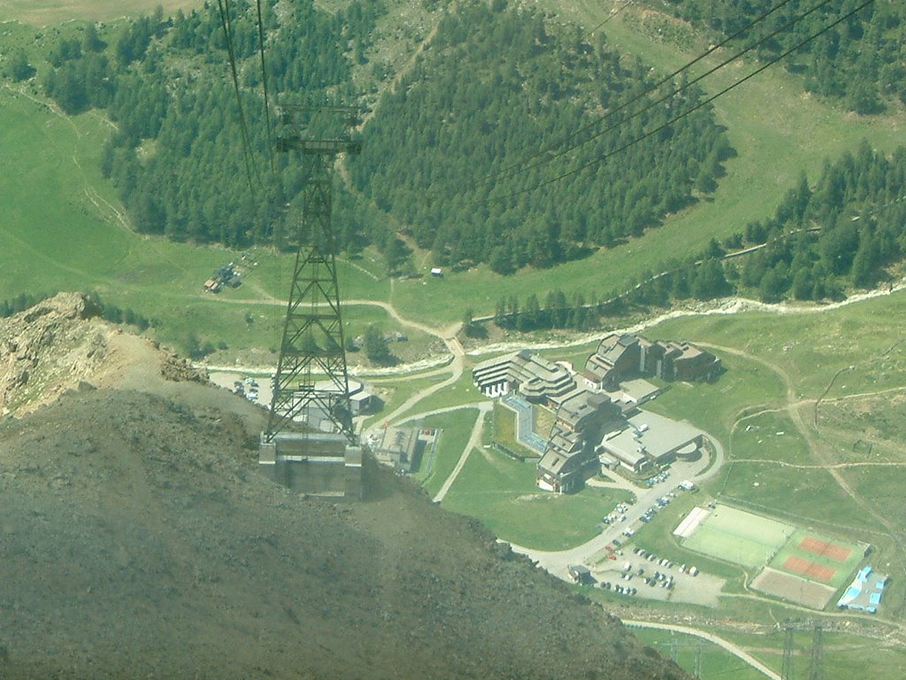
This is a photo from the Senales Valley in Italy. Even in the summer, there exists snow and many ski racing teams go there for training. It is saisd that the ice there is one of the best in Europe. The cabin which takes you to the chalet starts at the 2062 meters above sea level and reaches the 3212.
24 May 2006
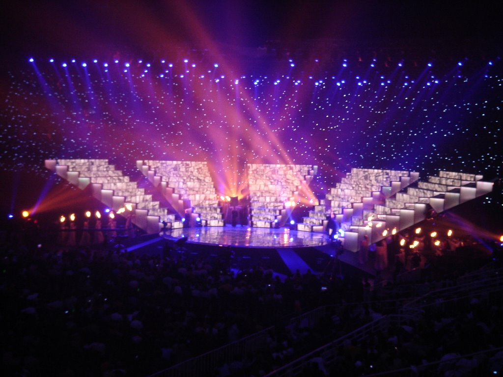
THE GRAND FINAL EUROVISION ATHENS 2006
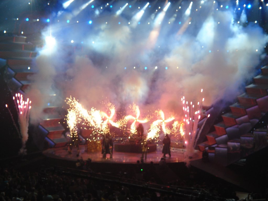
Finnish band Lordi may be the winners of the 51st Eurovision, but Greece was the one that stole the limelight.
03 May 2006

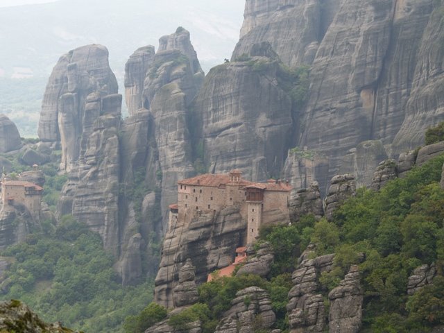
METEORA GREECE
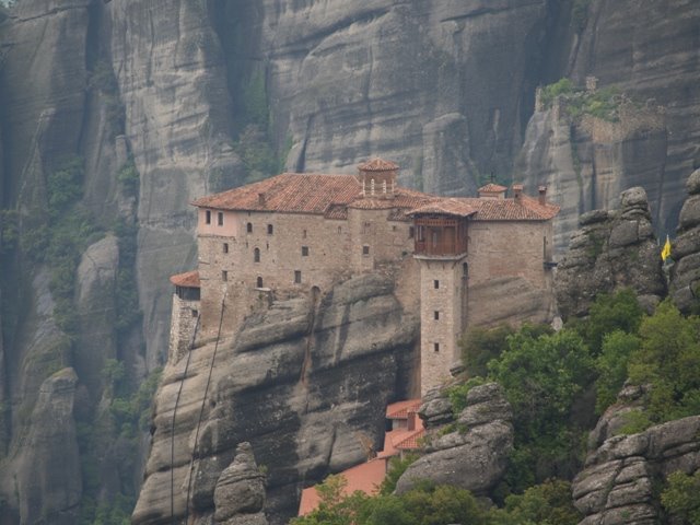
The Meteora (Greek: Μετέωρα, "suspended rocks" or "suspended in the air") is the largest and most important complex of monasteries in all of Greece, second only to Mount Athos. The monasteries are built on spectacular natural sandstone rock pillars, at the northwestern edge of the Plain of Thessaly near the Peneios river and Pindus Mountains, in central Greece. The Meteora is home to six monasteries and is included on the UNESCO World Heritage List.
Although it is unknown when Meteora was established, as early as the 11th century CE hermit monks were believed to be living among the caves and cutouts in the rocks. By the late 11th or early 12th century a rudimentary monastic state had formed called the Skete of Stagoi and was centered around the church of Theotokos (mother of God), which still stands today.The hermit monks, seeking a retreat from the expanding Turkish occupation, found the inaccessible rock pillars of Meteora to be an ideal refuge. Although more than 20 monasteries were built, beginning in the 14th century, only six remain today. These six are: 'Great Meteoron (or Transfiguration), Varlaam, St. Stephen, Holy Trinity, St. Nicholas Anapausas and Rousanou.
In the 1920s, steps were cut into the rock, making the complex accessible via a bridge from the nearby plateau. Of the six monasteries now inhabited, five are male, one female. Each monastery has fewer than 10 inhabitants and is visited by many tourists. The Agia Triada (Greek: Αγία Τριάδα, "Holy Trinity") monastery was used in the final scenes of the James Bond film For Your Eyes Only. http://www.meteora-greece.com
02 May 2006

29 March 2006
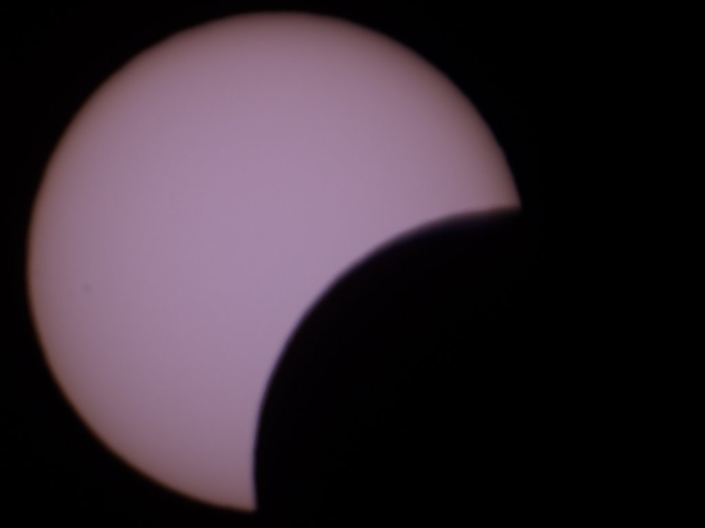

SOLAR ECLIPSE IN GREECE

A solar eclipse occurs when the Moon passes between Earth and the Sun, thereby totally or partially obscuring Earth's view of the Sun. This configuration can only occur during a new moon, when the Sun and Moon are in conjunction as seen from the Earth. In ancient times, and in some cultures today, solar eclipses are attributed to mythical properties. Total solar eclipses can be frightening events for people unaware of their astronomical nature, as the Sun suddenly disappears in the middle of the day and the sky darkens in a matter of minutes. However, the spiritual attribution of solar eclipses is now largely disregarded.
Total solar eclipses are very rare events for any given place on Earth because totality is only seen where the Moon's umbra touches the Earth's surface. A total solar eclipse is a spectacular natural phenomenon and many people consider travel to remote locations in order to observe one. The 1999 total eclipse in Europe, said by some to be the most-watched eclipse in human history, helped to increase public awareness of the phenomenon. This was illustrated by the number of people willing to make the trip to witness the 2005 annular eclipse and the 2006 total eclipse. The next solar eclipse takes place on September 11, 2007, while the next total solar eclipse will occur on August 1, 2008.http://sunearth.gsfc.nasa.gov/eclipse/eclipse.html
26 February 2006


Subscribe to:
Posts (Atom)